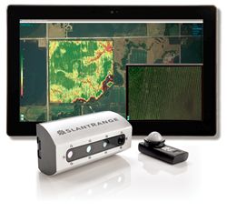
Bayer will be able to access SLANTRANGEs advanced data analytics to develop new high-throughput phenotyping techniques
Matthew Barre | SLANTRANGE
SLANTRANGE, a leading provider of next-generation drone-based remote sensing, analytics, and data services for agriculture announced today a new Data Collection and Analysis Agreement with Bayer CropScience LP, a world-leading agriculture enterprise with businesses in seeds, crop protection, and nonagricultural pest control.
“We are very excited to work with SLANTRANGE to support our research and development efforts into high-throughput phenotyping,” said Greta De Both, Global Crop Efficiency Manager for Breeding & Trait Development at Bayer. “SLANTRANGE’s industry-leading sensor and analytics technology adds valuable and unique new metrics to our research and breeding programs that will improve our ability to characterize plant development.”
Aerial remote sensing using drones has emerged as a powerful and efficient technology to gain valuable new insights into crop performance in both research and commercial settings. The agreement provides funding to deploy and evaluate SLANTRANGE’s proprietary airborne sensor and analytics technology on three key crops within Bayer’s Crop Efficiency Research Program during the 2017 North American growing season. The work will be focused on collecting and analyzing data on various crop phenotypes as a means of assessing genotype and/or treatment performance. The data products will include basic crop metrics such as stress conditions and biomass as well as advanced custom analytics leveraging SLANTRANGE’s multispectral signature processing and machine vision techniques.
The results will be used to evaluate how high-resolution drone-based imagery and advanced data analytics can be used in conjunction with other geo-referenced data sources, such as soil characterization, weather time-series, and satellite data, to gain new agronomic insights and provide more customized and sustainable agronomic recommendations for improving yields.
“The Bayer team is the ideal company to take full advantage of the power and scalability of our analytics solutions,” said Michael Ritter, CEO of SLANTRANGE. “This agreement represents our ongoing commitment to be the world’s leading source of agricultural crop information.”
About Bayer
Bayer is a global enterprise with core competencies in the Life Science fields of health care and agriculture. Its products and services are designed to benefit people and improve their quality of life. At the same time, the Group aims to create value through innovation, growth, and high earning power. Bayer is committed to the principles of sustainable development and to its social and ethical responsibilities as a corporate citizen. In fiscal 2016, the Group employed around 115,200 people and had sales of EUR 46.8 billion. Capital expenditures amounted to EUR 2.6 billion, R&D expenses to EUR 4.7 billion. These figures include those for the high-tech polymers business, which was floated on the stock market as an independent company named Covestro on October 6, 2015. For more information, go to http://www.bayer.com.
About SLANTRANGE
SLANTRANGE is an agricultural intelligence company that develops and markets sensors and analytics systems designed specifically for the needs of farmers. By quickly providing insights from the field, SLANTRANGE gives farmers more control over agricultural land, helping to reduce operational costs and improve decision making. To learn more, please visit http://www.slantrange.com.
The content & opinions in this article are the author’s and do not necessarily represent the views of AgriTechTomorrow
Comments (0)
This post does not have any comments. Be the first to leave a comment below.
Featured Product


