XAG Displayed the Promising Future of Agriculture Drone at the 3rd Drone World Congress

The 3rd Drone World Congress 2019, in conjunction with the 4thShenzhen International UAV Expo, was held in Shenzhen, China, from June 20th to 22nd. Themed with "Better Technology, Better Life", the congress emphasised the industry applications of drones in agriculture, public safety, land management, civil aviation, environmental protection, disaster rescue, etc. Over 400 enterprises worldwide were present at the event with more than 1,000 drones and other cutting-edge technologies such as AI, IoT and robotics.
As a leading agriculture technology company and industrial UAV manufacturer, XAG has developed its own patented agriculture drones, sensors and other digital farming tools for precision spraying, granule spreading and mapping. To date, XAG has conducted UAV plant protection services on over 6 million hectares of farmlands and served 4.74 million farmers.
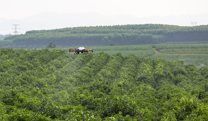
At the expo, XAG demonstrated its drone-based smart agriculture solutions on how to sustainably grow crops and effectively manage farmlands with less chemical use. Perfectly designed for precision agriculture, the XAG P Series Plant Protection UAS is equipped with the industry-graded SUPERX3 Pro RTK flight control system which provides high-accuracy navigation at centimetre level while enabling fully autonomous flying and obstacle avoidance at all kinds of terrains. Its intelligent spraying system can atomise liquids into micron-level droplets and significantly reduce drifting so that pesticides are precisely applied to the target area.
The XMission Multifunctional UAS, light and foldable, can be mounted with various cameras modules for field mapping, remote sensing monitoring and data collection on crop growth. It can precisely conduct aerial operation with ease in different scenarios and accomplish 2D/3D terrain modelling for complex environment.
The congress also hosted 30 parallel forums and invited 300 internationally recognised industry experts to discuss the future prospect of UAV technology as well as defining industry standards. Peng Bin, Founder and CEO of XAG, gave a keynote speech about the future of agriculture drone at the International Conference of Precision Agricultural Aviation, addressing the pivotal role of drone technology in building a sustainable agriculture ecosystem.
Not only have drones been effectively utilised to establish digital farming infrastructure and transform the traditional agriculture production approach, but with the vast troves of data collected, they also lay the foundation to achieve a traceable food value chain as well as generating AI-based agriculture solutions. Drones have become a bigger part of smart farming's future.
Peng shared stories on how XAG has been helping farmers increase food productivity and improve their livelihood, for example, by applying drones to orchard management and rice seeding.
Traditionally, managing orchards, especially the ones located on mountainous or hilly terrains, is a physically difficult and time-consuming task, since fruit growers had to manually collect data and conduct hand spraying for pest control. Now, farmers can free themselves from an overwhelming amount of physical labour, through the collaboration between drone and AI technology.
First, the centimetre-level surveying UAS XMission flies over the orchard to capture high-definition field images with minimal errors. Then, XAG Agriculture Intelligence (XAI) is set to carry out intelligent analysis of the orchards, automatically identifying the boundaries and obstacles as well as calculating the statistics of fruit trees. The position of each fruit tree, including its centre and perimeter, can even be accurately pinpointed with the recall ratio and precision ratio reaching as high as 98.60% and 98.04% respectively.
These AI-backed HD maps can be directly applied to XAG P Series Plant Protection UAS for autonomous, precise spraying over the targeted area. Users only need to pre-set flight and spraying parameters before the drone operation automatically kicks off.
In addition, agriculture drones are also being leveraged to empower farmers for precision seeding. When more and more countries are facing the intractable problem of agriculture labour shortage and increasing labour costs in rural areas, the old-fashioned seeding approach heavily relied on physical work is in dire need of disruption.
In terms of rice field seeding, a walking-type transplanter, requiring 3 to 4 labours to operate, can only cover 2 hectares of farmlands per day. And most granule spreading drones currently available in the market do not have an optimised design to guarantee output volume or spreading accuracy.
By contrast, based on the P Series plant protection UAS platform, XAG has designed the JetSeed™ Granule Spreading System which, with high-speed airflows and rolling feeder, can project demanded dosage of seeds and fertilisers uniformly into wherever it is needed. The efficiency of drone operation proves to reach up to 5 hectares per hour, 150 times faster than manual seeding and 5 time faster than the high-speed transplanter.
The future of agriculture drones is full of endless possibilities, as its application scenarios are constantly expanding from plant protection, field mapping to seeding. This new technology might make an impact on other territories such as fishery, forestry, ecological restoration and disease control.
By incorporating drones, AI, IoT and cloud computing technology into the management of crops, XAG will continue to accelerate the inclusive development of smart farming, increasing food production without consuming excessive resources or compromising food quality.
Comments (0)
This post does not have any comments. Be the first to leave a comment below.
Featured Product

